

Vaizdas:Ancient balkans 4thcentury.png

Didesnės raiškos iliustracija (1 115 × 845 taškų, rinkmenos dydis: 88 KiB, MIME tipas: image/png)
Šis paveikslėlis buvo įkeltas iš commons:commons. Žr. Originalus aprašymas buvo:
| Aprašas |
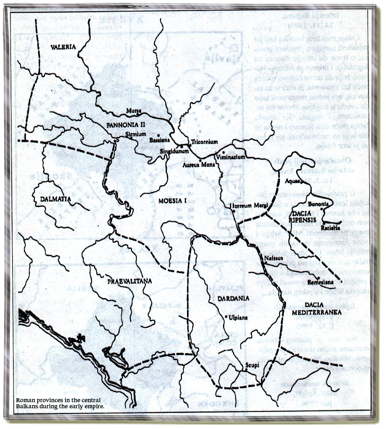
angl. Ancient Roman Balkans in the 4th century.serb. Antički rimski Balkan u 4. veku. |
|---|---|
| Šaltinis |
Mano darbas - based on data from published sources and web sources (including Euratlas - http://www.euratlas.net/history/europe/300/europe_map_0300.html ) |
| Data |
2008 (first version); 2008 (last version) |
| Autorius |
Original uploader and author was PANONIAN at en.wikipedia. Later version(s) were uploaded by Olahus at en.wikipedia and by PANONIAN at Wikimedia Commons. |
| Leidimas |
Released into the public domain (by the author). |
Licencija:
| Aš, kaip paveikslėlio autorius, skelbiu, kad failas gali būti viešai naudojamas. |
References
- Sima M. Ćirković, Srbi među evropskim narodima, Beograd, 2004.
- Denis Šehić - Demir Šehić, Istorijski atlas Sveta, Beograd, 2007.
- http://www.euratlas.net/history/europe/300/europe_map_0300.html
- http://xxlworld.xx.ohost.de/povijest/slike/mape/3-5cen.jpg
- http://www.geocities.ws/lajme8reja/1111111111dardania.JPG
- http://www.orbilat.com/Maps/Latin/Balkan_Latin.gif
- http://soltdm.com/geo/arts/delta/hierocl.jpg
Original upload log
The original description page is/was here. All following user names refer to en.wikipedia.
- 2008-03-07 19:53 Olahus 1300×943× (115351 bytes)
- 2008-02-20 20:17 PANONIAN 1300×943× (143691 bytes) my own work {{PD-self}}
| date/time | username | resolution | size | edit summary |
|---|---|---|---|---|
| 2010-04-08T11:34:26Z | PANONIAN | 1115×845 | 90568 | Reverted to version as of 11:22, 8 April 2010 - fixing thumbnail problem |
| 2010-04-08T11:32:39Z | PANONIAN | 1115×845 | 90931 | Reverted to version as of 00:04, 7 March 2010 - fixing thumbnail problem |
| 2010-04-08T11:22:32Z | PANONIAN | 1115×845 | 90568 | correction |
| 2010-03-07T00:04:44Z | PANONIAN | 1115×845 | 90931 | corrected mistake |
| 2010-03-06T23:24:44Z | PANONIAN | 1115×845 | 90863 | improved version |
| 2009-09-04T13:01:00Z | Penn Station | 1300×943 | 115351 | {{Information |Description=Own work by authors(PANONIAN, Olahus). Ancient balkans 4thcentury. |Source=File:Ancient balkans 4thcentury.png |Date=19:53, 7 March 2008 |Author=PANONIAN, Olahus |Permission= |other_versions= }} {{PD-user-en|PANONIAN, Olahus}} |
Rinkmenos istorija
Paspauskite ant datos/laiko, kad pamatytumėte rinkmeną tokią, kokia ji buvo tuo metu.
| Data/Laikas | Miniatiūra | Matmenys | Naudotojas | Paaiškinimas | |
|---|---|---|---|---|---|
| dabartinis | 2012 m. rugpjūčio 14 d., 18:02 | | 1 115 × 845 (88 KiB) | VP-bot1 (Aptarimas | indėlis) | Šis paveikslėlis buvo įkeltas iš commons:commons. Žr.Kategorija:Iš vikitekos Originalus aprašymas buvo: {{Information |Description={{en|Ancient Roman Balkans in the 4th century.} |
Jūs negalite perrašyti šios rinkmenos.
Paveikslėlio naudojimas
Paveikslėlis yra naudojamas šiuose puslapiuose:
- Iš vikitekos
- PD-self
- Maps of the history of the Balkans
- Maps of the history of Croatia in ancient times
- Maps of the history of Dalmatia
- Maps of the history of Slavonia
- Maps of the history of Bosnia and Herzegovina in ancient times
- Maps of the history of Republika Srpska
- Maps of the history of Montenegro in ancient times
- Maps of the history of Serbia in ancient times
- Maps of the history of Vojvodina
- Maps of the history of Syrmia
- Maps of the history of Kosovo in ancient times
- Maps of the history of Albania
- Maps of the history of the Republic of Macedonia
- Maps of Roman provinces
- Maps of Illyricum
- Maps of Pannonia
- Maps of Roman Dacia
- Roman provinces (Balkans)
- Praevalitana
- Dardania (Roman Empire)
- Moesia Superior & Inferior
- Dalmatia (Roman Empire)
- Goths
- Iazyges
- Maps of Roman Praevalitana