

Vaizdas:Brazil-16-map.jpg
Brazil-16-map.jpg (379 × 516 taškų, rinkmenos dydis: 277 KiB, MIME tipas: image/jpeg)
| Ši byla yra iš bendros Wikimedia Commons nemokamų resursų duomenų bazės, palaikomos Wikimedia Foundation organizacijos. Norėdami sužinoti licencijavimo smulkmenas, žiūrėkite paveikslėlio aprašymą | Į paveikslėlio aprašymą |
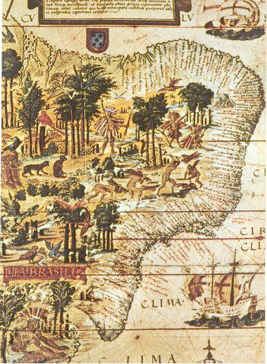
| Aprašymas | Map of Brazil in the Miller Atlas of 1519. Scan from 《社会历史博物馆》 ISBN 7-5347-1397-8 "社会历史博物馆" / "Social Historical Museum" 16世纪巴西的地图 / The map of Brasil in 16th century 1519年葡萄牙人绘制 / Issued in Portugal in 1519 |
| Data | Brazil 1500 |
| Šaltinis | scan from 《社会历史博物馆》 ISBN 7-5347-1397-8 |
| Autorius | 《社会历史博物馆》 |
| Kitos versijos |
 |
|
Šis failas yra viešo naudojimo tose šalyse, kuriose autorių teisės galiojimo netenka po 70 metų nuo autoriaus mirties.
| |
| This file has been identified as being free of known restrictions under copyright law, including all related and neighboring rights. | |
Rinkmenos istorija
Paspauskite ant datos/laiko, kad pamatytumėte rinkmeną tokią, kokia ji buvo tuo metu.
| Data/Laikas | Miniatiūra | Matmenys | Naudotojas | Paaiškinimas | |
|---|---|---|---|---|---|
| dabartinis | 2005 m. birželio 6 d., 22:00 | | 379 × 516 (277 KiB) | wikimediacommons>Shizhao | scan from 《社会历史博物馆》 ISBN 7-5347-1397-8 16世纪巴西的地图 1519年葡萄牙人绘制 {{PD}} |
Paveikslėlio naudojimas
Paveikslėlis yra naudojamas šiuose puslapiuose: