

Vaizdas:North West England counties 2009 map.svg

Rinkmenos SVG peržiūros PNG dydisː 300 × 599 taškų. Kitos 6 rezoliucijos: 120 × 240 taškų | 240 × 480 taškų | 385 × 768 taškų | 513 × 1 024 taškų | 1 026 × 2 048 taškų | 674 × 1 345 taškų.
Didesnės raiškos iliustracija (SVG rinkmena, formaliai 674 × 1 345 taškų, rinkmenos dydis: 1,39 MiB)
| Ši byla yra iš bendros Wikimedia Commons nemokamų resursų duomenų bazės, palaikomos Wikimedia Foundation organizacijos. Norėdami sužinoti licencijavimo smulkmenas, žiūrėkite paveikslėlio aprašymą | Į paveikslėlio aprašymą |
Aprašymas
| Aprašymas |
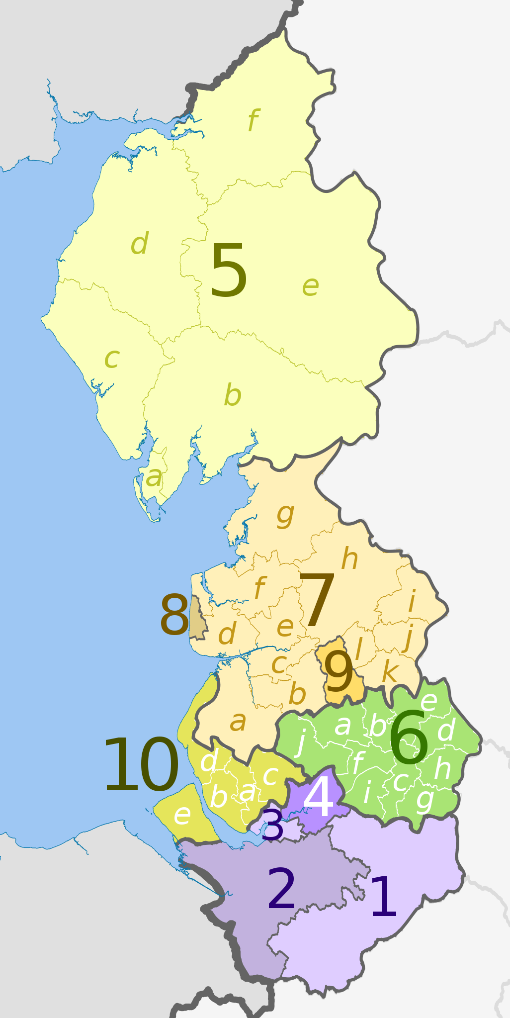
English: Map of the North West England region, showing its counties and administrative districts until 31 March 2023. The county colours are the same as those in File:English metropolitan and non-metropolitan counties 2009.svg.
For counties since 1 April 2023, see File:North West England counties 2023 map.svg. Equirectangular map projection on WGS 84 datum, with N/S stretched 170% Geographic limits:
|
| Data | (UTC) |
| Šaltinis |
Šis failas buvo kilęs iš: |
| Autorius |
|
| Kitos versijos | File:North West England counties 2023 map.svg – version since 1 April 2023 |


| Map | Ceremonial county | County/Unitary | Metropolitan/non-metropolitan districts |
|---|---|---|---|
 |
Cheshire | 1. Cheshire East U.A. | |
| 2. Cheshire West and Chester U.A. | |||
| 3. Halton U.A. | |||
| 4. Warrington U.A. | |||
| 5. Cumbria † | a) Barrow-in-Furness, b) South Lakeland, c) Copeland, d) Allerdale, e) Eden, f) Carlisle | ||
| 6. Greater Manchester * | a) Bolton, b) Bury, c) Manchester, d) Oldham, e) Rochdale, f) Salford, g) Stockport, h) Tameside, i) Trafford, j) Wigan | ||
| Lancashire | 7. Lancashire † | a) West Lancashire, b) Chorley, c) South Ribble, d) Fylde, e) Preston, f) Wyre, g) Lancaster, h) Ribble Valley, i) Pendle, j) Burnley, k) Rossendale, l) Hyndburn | |
| 8. Blackpool U.A. | |||
| 9. Blackburn with Darwen U.A. | |||
| 10. Merseyside * | a) Knowsley, b) Liverpool, c) St. Helens, d) Sefton, e) Wirral | ||
Key: †shire county | *metropolitan county
Licencija
Šiam failui taikoma Creative Commons Attribution-Share Alike 3.0 Unported licencija.
Autoriaus nurodymas: Dr Greg and Nilfanion. Contains Ordnance Survey data © Crown copyright and database right 2011
- Jūs galite:
- dalintis – kopijuoti, platinti bei persiųsti šį darbą
- pri(si)taikyti – adaptuoti darbą
- Su šiomis sąlygomis:
- autoriaus nurodymas – Turite pateikti atitinkamą kreditą, pateikti nuorodą į licenciją ir nurodyti, ar buvo atlikti pakeitimai. Tai galite padaryti bet kokiu būdu, bet ne taip, kad licencijos išdavėjas patvirtintų jus ar jūsų naudojimą.
- dalinkis panašiai – Jei perdirbsite, redaguosite ar atkursite šį darbą, jį galėsite platinti tik su tokia pačia ar panašia į šią licencija.
Originalus įkėlimo įrašas
This image is a derivative work of the following images:
- File:North_West_England_districts_2011_map.svg licensed with Cc-by-sa-3.0, GFDL
- 2011-05-01T19:03:10Z Nilfanion 674x1345 (1403071 Bytes) == Summary == {{Information |Description=Map of the [[w:North West England|North West England]] region showing the administrative districts. Equirectangular map projection on WGS 84 datum, with N/S stretched 170% Geographic
- File:English_ceremonial_counties_2010.svg licensed with Cc-by-sa-3.0, GFDL
- 2010-11-23T16:39:55Z Nilfanion 1108x1345 (308868 Bytes) thicker lines
- 2010-11-23T16:20:19Z Nilfanion 1108x1345 (301520 Bytes) tweaks
- 2010-10-26T20:34:20Z Nilfanion 817x990 (1391832 Bytes) {{Information |Description=Map showing the [[w:ceremonial counties of England]] including the City of London, in 2010. Equirectangular map projection on WGS 84 datum, with N/S stretched 170% Geographic limits: *West: 6.75W
Uploaded with derivativeFX
Rinkmenos istorija
Paspauskite ant datos/laiko, kad pamatytumėte rinkmeną tokią, kokia ji buvo tuo metu.
| Data/Laikas | Miniatiūra | Matmenys | Naudotojas | Paaiškinimas | |
|---|---|---|---|---|---|
| dabartinis | 2012 m. gegužės 5 d., 23:08 | | 674 × 1 345 (1,39 MiB) | wikimediacommons>Dr Greg | lighten black boundary line |
Paveikslėlio naudojimas
Paveikslėlis yra naudojamas šiuose puslapiuose: