

Vaizdas:Carte Hollande 1843.jpg

Didesnės raiškos iliustracija (2 400 × 3 235 taškų, rinkmenos dydis: 3,66 MiB, MIME tipas: image/jpeg)
| Ši byla yra iš bendros Wikimedia Commons nemokamų resursų duomenų bazės, palaikomos Wikimedia Foundation organizacijos. Norėdami sužinoti licencijavimo smulkmenas, žiūrėkite paveikslėlio aprašymą | Į paveikslėlio aprašymą |
Aprašymas
| Aprašymas |
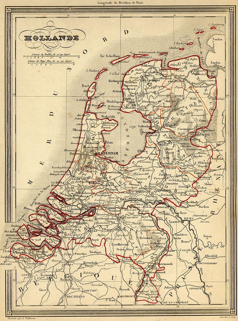
Français : Carte géographique ancienne des Pays-Bas (wp-FR) avec noms en français dressée par le géographe Alexandre Vuillemin en 1843 extraite de son “Atlas universel de géographie ancienne et moderne à l'usage des pensionnats”. Le titre original de cette carte est “Hollande”.
Sur cette carte de 1843, la rectification de frontière de 1839 transférant le Limbourg oriental et Maastricht de la Belgique aux Pays Bas est intégrée. Cet atlas était initialement monochrome mais son premier propriétaire a réhaussé manuellement en couleur les frontières ou limites administratives.English: French map of the Netherlands (wp-EN). Made by Alexandre Vuillemin and taken from his "Atlas universel de géographie ancienne et moderne à l'usage des pensionnats", 1843. |
| Data | |
| Šaltinis | |
| Autorius | Alexandre Vuillemin (reproduit par histoirepostale.net) |
Licencija
This image is in the public domain because it is a mere mechanical scan or photocopy of a public domain original, or – from the available evidence – is so similar to such a scan or photocopy that no copyright protection can be expected to arise. The original itself is in the public domain for the following reason:
This tag is designed for use where there may be a need to assert that any enhancements (eg brightness, contrast, colour-matching, sharpening) are in themselves insufficiently creative to generate a new copyright. It can be used where it is unknown whether any enhancements have been made, as well as when the enhancements are clear but insufficient. For known raw unenhanced scans you can use an appropriate {{PD-old}} tag instead. For usage, see Commons:When to use the PD-scan tag.  | ||||
Rinkmenos istorija
Paspauskite ant datos/laiko, kad pamatytumėte rinkmeną tokią, kokia ji buvo tuo metu.
| Data/Laikas | Miniatiūra | Matmenys | Naudotojas | Paaiškinimas | |
|---|---|---|---|---|---|
| dabartinis | 2007 m. lapkričio 18 d., 17:54 | | 2 400 × 3 235 (3,66 MiB) | wikimediacommons>Dlebouc | {{Information |Description= {{fr|Carte géographique ancienne des '''Pays-Bas''' (wp-FR) avec noms en français dressée par le géographe Alexandre Vuillemin en 1843 extraite de son “Atlas universel de géographie ancienne et moderne |
Paveikslėlio naudojimas
Paveikslėlis yra naudojamas šiuose puslapiuose: